Source: History.com
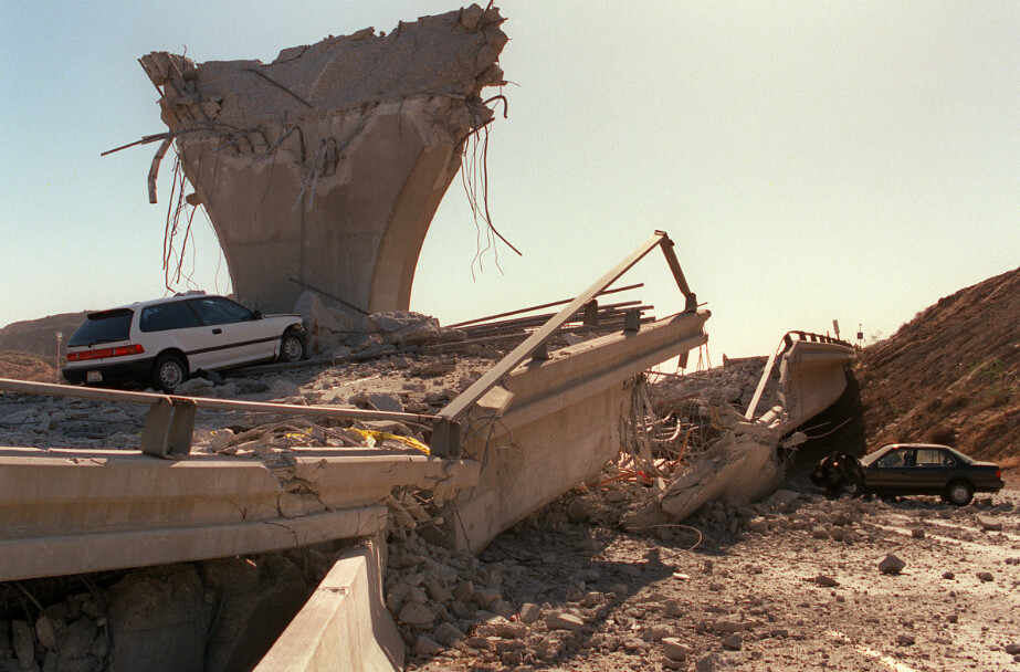
Today marks the 25th Anniversary to the Northridge Earthquake (in Northridge, California). Natural disasters seem to be more frequent these days. Climate change has been the usual culprit to claim. Regardless of what your opinion on the matter is, anytime reliable information can come down various news / information outlets (which are respectable sources of information), residents enjoy having any (if little) warning to prepare for a disaster. Mayor Eric Garcetti along with the United States Geological Services developed an app for a smartphone which would give a resident just a few seconds before an earthquake hits. How does the app work? What does the app look like? These questions are answered in brief below.
In a recent article in 'Wired' titled "LOS ANGELES GETS AMERICA'S FIRST EARTHQUAKE WARNING APP" the app is introduced as follows:
On January 3, Los Angeles Mayor Eric Garcetti announced the release of ShakeAlertLA, a new earthquake-warning app for residents of Los Angeles County. The app—the first of its kind in the United States—promises to “save lives by giving precious seconds to you and to your family to take action and to protect yourselves,” Garcetti told reporters at a launch event at City Hall.Available to download in both English and Spanish in the Apple and Google Play stores, ShakeAlertLA is designed to give smartphone users a warning, with sound, of earthquakes of 5.0 magnitude or larger, a few seconds or more before the shaking begins. That’s not a lot of time, but even a brief window can be enough to gather family members and “drop, cover, and hold on,” as earthquake drills instruct.
According to the 'ShakeAlertLA' website, the purpose of the app is to give enough warning which would allow a whole host of organizations and utilities to be shutdown or slowed down to save lives and reduce cost of damages incurred:
Studies of earthquake early warning methods in California have shown that the warning time would range from a few seconds to a few tens of seconds. ShakeAlert can give enough time to slow trains and taxiing planes, to prevent cars from entering bridges and tunnels, to move away from dangerous machines or chemicals in work environments and to take cover under a desk, or to automatically shut down and isolate industrial systems. Taking such actions before shaking starts can reduce damage and casualties during an earthquake. It can also prevent cascading failures in the aftermath of an event. For example, isolating utilities before shaking starts can reduce the number of fire initiations.
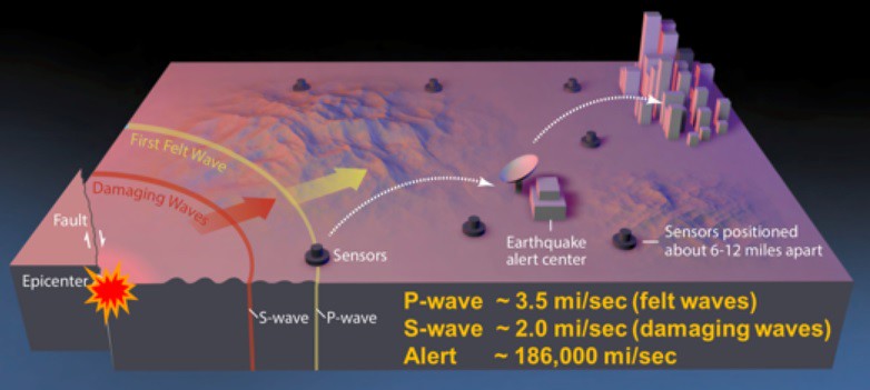
Wow. Amazing. Right about now you may be wondering how exactly the job is accomplished of measuring the threat and then conveying a threat of a geological disaster.
Source: ShakeAlertLA
In the diagram above, the lower left hand corner shows the origin of the emerging earthquake or the 'epicenter' of the quake. As the different waves (p-waves and s-waves) propagate outward at different speeds, the detectors sense the waves and send them throughout the notification/emergency network.
To see a more fluid (or action) based presentation of the ShakeAlert system, I consulted Google. A search on YouTube turned up the video shown below produced by a host of organizations listed at the end of the short video (less than 5 minutes):
The major take home messages from the video are shown below in still photos taken from the video above. To begin with, again, ShakeAlert is possible with a variety of 'sensors' embedded in the ground around the Southern California region which serve to notify the appropriate earthquake research centers of an emerging earthquake forming as shown below:

Source: ShakeAlert
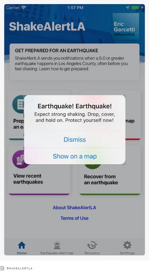
In the video screenshot above, the sensors which are embedded in the ground serve as the first indication of an emerging earthquake. These sensors measure both types of wave shown above -- namely 'p-waves' and 's-waves' -- which differ in speed and magnitude. Once the sensors detect a wave, the signal is transmitted to throughout the system which eventually arrives on your smartphone screen as shown below:
Source: ShakeAlertLA
The screen reads "Earthquake! Earthquake! Expect strong shaking. Drop, cover, and hold on. Protect yourself now!" This message is followed by two options: "Dismiss" or "Show on a map." At the very least, getting an initial warning can save lives - which I will touch upon shortly. First, the map of the emerging earthquake and zones (with arrival times) are shown below:

Source: ShakeAlert
The radial zones with different times are useful in notifying different geographical areas of the emerging quake. In some areas depending on the quality of the measurement, more than a minute of warning is possible. The more time amounts to in certain cases a reduced number of accidents or deaths (in some cases).
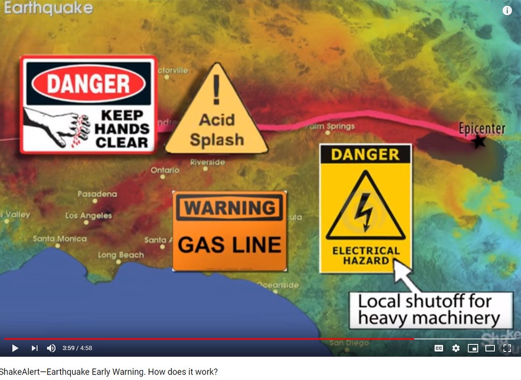
A wide range of industries could use a proper warning which are not usually considered by the average person. Think of the industries such as chemical or processing industries which are working with dangerous chemicals. Other industries which use heavy equipment could reduce harm by giving operators enough time to shut down equipment and take shelter. Below is a screenshot indicating just a few industries are shown:
Source: ShakeAlert
Additionally, consider larger agencies such as transit agencies which operate buses and train systems on a city wide scale (or county). The earlier warning could give operators enough time to shut down certain train lines which might have previously 'derailed' and caused large amounts of casualties. What about airports? Air traffic controllers who help navigate pilots flying large commercial aircraft might be operating systems which could potentially lose power and cause major flight disruptions. The controllers could notify pilots of a potential (momentary) disruption which would help pilots have a greater ease of minds instead of presenting uncertainty about the exact events unfolding on the ground. Safety is better when there is a greater amount of time and information surrounding a natural disaster.
Conclusion...
The technology above serves to reduce the fall-out of a given earthquake (natural disaster) by giving residents and corporations along with government agencies proper warning (a few seconds to minutes) to take safety precautions necessary. What is the result? Less disaster. Less harm to environment and people. The science behind this model have been built out and tested to produce an app which is worthy of use by civilians.
When I first heard about earthquake warning systems, I was thinking about climate change. Climate change is also based on models. The information used as input into the models might be as accurate or even more accurate than the information inputted into the app shown above. Heading into the future, I would hope that as an earthquake occurs and the app serves as notification, each person comes to rely on the app to provide information which is reliable. Further, a question will inevitably arise in each of our minds regarding the reliable information (and our trust of the app over time): Why do we trust the app regarding earthquakes, but choose not accept the science behind climate change? Why trust some science while disregarding other science? These are questions to entertain as we move forward into the future and rely more on 'sensor technology' -- which in turn will provide greater accuracy of a measurement (hence, more reliable data).
Related Blog Posts:
Science Topics, Thoughts, and Parameters Regarding Science, Politics, And The Environment!
No comments:
Post a Comment