Wayfinding Signage?
What is 'wayfinding' signage? What is the utility of such signage? What does that signage look like? All of these questions are acceptable in this day and age. Especially as different urban areas try to transition toward designing downtown regions which motivate residents and tourists to engage in greater active modes of transportation -- when moving around.
Here is an example of a 'wayfinding' sign in Glendale (California, USA) shown below:
Source: Roger Wilson/LA Times
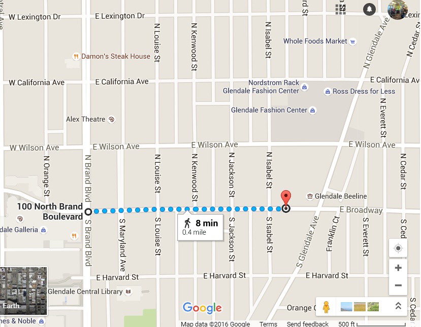
Upon inspection of the sign in the picture above, there is a time printed on the sign and a destination. In this case, the time that a person would have to walk (7 minutes) from this point to the shops on Brand Blvd. Here is an image of a map taken from GoogleMaps outlining the distance stated on the sign below:
The sign shown in the picture above was taken from an article in the Sunday 'LA Times' titled "New 'wayfinding signs' encourage pedestrians to take a stroll around Glendale." Among the paragraphs in the story, three stood out in particular. The first excerpt highlights the reason for the signs as shown below:
Dubbed "wayfinding signs," the signage along local sidewalks serves two purposes: they contain health tips and point in the direction of local landmarks such as the Glendale Galleria and the Americana at Brand."We're thinking they'd be helpful for visitors, people who may not necessarily be familiar with all the sights and attractions here in town, and residents may find a hidden jewel in their neighborhood," said Juan Gonzalez, neighborhood services supervisor for the city.
The City of Glendale has the correct intentions for tourists. Although, tourists should not be the only audience that transportation experts are targeting. The overall mission of transportation authorities should be to target everyone living within walking/biking distance (<3 miles) of the downtown area. Especially, as this mission is aligned with the mission of Measure R2 and with Governor Jerry Brown's vision of engaging a greater population in using active modes of transportation (i.e., motivating active transportation). For those who are unfamiliar with Measure R2, the measure is a huge transportation bill to be added to November's ballot -- which will supply billions of dollars over the next few decades (read more here).
These distances can easily be traveled safely and quickly by bicycle - but remain unknown to the average resident who mainly relies on their vehicle to travel short distances (which is astounding). Additionally, the city should be emphasizing the relative distances associated with traveling within the "downtown area" of Glendale. Here is a map of South Glendale (that is below the 134 Fwy) shown below:
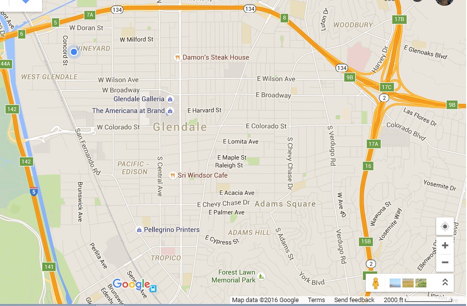
The scale is located at the bottom right. As the reader can see, the entire "downtown" area (including residential areas surrounding downtown) spans may 2 miles wide by 3 miles in length (running North to South). Residents could easily walk and bike around the area where all of the major business is conducted if they had a better grasp of the relative dimensions of the city.
One of the main motivations of writing for this blog site is to demystify reported statistics in the popular news using dimensional analysis. Viewing a map in context to scale and relative distances, should motivate residents of the area -- not just tourists to walk and bike rather than drive.
In the first map shown above, the time that a person needs to travel from City Hall to Brand Blvd is only 8 minutes. I wonder how many of the public employees who work at City Hall (Council members and Mayor) walk to Brand Blvd for lunch? Furthermore, how many of the politicians walk the city rather than drive? Maybe that is a question that needs to asked of the city in the near future.
The lack of participation in active transportation seems to be mainly centered around awareness. Residents in the city have not the awareness of the relative times that is required of them to travel the relative distances. As usual, I try not to bring any subject up if I am unwilling to help in increasing the awareness -- which I have in the past.
How Long Does It Take To Walk Downtown?
Understanding the relative times that is required to travel a certain distance is critical in motivating the use of active modes of transportation. I have written on this site previously about eliminating the separation of commuting and leisurely trips when it comes to active transportation. Every trip should be an active transportation trip!
What is our part in the process?
We started the nonprofit organization 'Bikecar101' -- with a mission of the following: to advocate for and educate the public about bicycle on public transit trains. How does this correlate to the subject at hand -- wayfinding?
and the other video:
In each video, we started the experiments from the West side of town. From our house, we traveled to the center (to the Americana) and to the East side (to the fountain - second video). Which means that if residents are willing to walk around a mile each way, there is no need to use a car.
Of course, if the purpose of the trip is to buy groceries (in large quantities) or heavy objects from the mall, that is an exception to the rule. Think about how much healthier the residents of Glendale would be if there was a higher participation in active transportation. In the article above, the distance highlighted by the 8 minute walk drove home the point that anyone living in the vicinity of City Hall does not need to drive (every time) to get to Brand. Plus, here is an excerpt from the article highlighting the health benefits:
As for health tips, one of the signs states that doctors recommend walking 6,000 steps a day to improve one's health and 10,000 a day to lose weight.
There's also a social-media campaign as part of the program. Pedestrians are encouraged to snap selfies of themselves with a wayfinding sign in the shot and share the pictures on social media with the hashtag #GlendaleWalks.
Any person can easily achieve 10,000 steps by traveling using active transportation in a given day. There is no excuse. The information is present in the article. You might ask then the following question:
What is wrong with the article?
Conclusion...
Again, the 'wayfinding' signs are a wonderful addition to the City of Glendale. I hope that as the transportation experts around the Southern California area move forward in motivating voters to go out and support Measure R2 this November, we remember the overall mission. It is imperative that the all active modes of transportation be emphasized. Walking, biking, along with the use of light rail, bus rapid transit affords the opportunity to travel over a wide range of distances here in Southern California. In order to drive home the concept, each of us advocates need to demystify the distances that are available to walk/bike in our respective cities.
'Wayfinding' signs contribute greatly to this effort. Although, if each of us do not contribute and explain to our fellow citizen the purpose of these additions (signage), then they will go unnoticed. Walking/biking is demystified by various exercise groups on the weekends along with local bicycle coalitions (the Los Angeles County Bicycle Coalition hosts a Sunday "Fun day" ride each month). Working together, come November, Measure R2 will become a reality. Then the real work continues to be our duty -- spread the word by education to produce a better society. Each City needs to work together to become a region promoting healthy and sustainable transportation. Infrastructure and tourism is just one part of a larger solution.
To stay informed on transportation, infrastructure, and advocacy issues in the region read the vast coverage (while up to date) at StreetsblogLA.org.
No comments:
Post a Comment